Posts

Showing posts from October, 2022

"The Communities of Cornwall Across Time"
Image
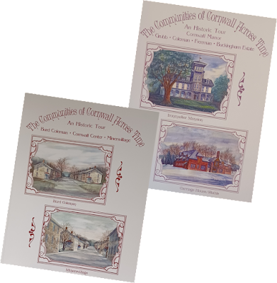
If you are interested in Cornwall Borough history, you must avail yourself of a wonderful book series called "The Communities of Cornwall Across Time." So far authors Michael A. Trump and L. Susan Wentzel have published two volumes in the four-volume series, with the gracious editorial assistance from Kathy J. Donaldson and Karin Mitchell. Book 1 contains "An Historic Tour: Burd Coleman, Cornwall Center, Minersvillage," 124 pages of fascinating photographs and descriptive stories of the villages, historic houses, railroads and local industry. Just one example is a pictorial history of the Cornwall Ore Bank "Loading Pocket" building that was recently demolished. Book 2 is "An Historic Tour: Cornwall Manor, Grubb, Coleman, Freeman, Buckingham Estate." It is an exhaustive 193-page pictorial history of the family and buildings in the late 19th century and up through the 20th century story of present-day Cornwall Manor. The large 8.5 x 11 form...

"The Story of Cornwall (In Case You Missed It)"

Image
There is a second monument in Cornwall center that is perhaps less noticeable than the bronze monument to the Cornwall miner. While the miner stands more prominently near the four corners of the 419 intersection, the great stone slab pictured here stands by the Borough Police Station. As it attests, this monument was erected by Bethlehem Steel Corporation in 1976. The full story is "chiseled in stone."   The Story of Cornwall “Presented to the Borough of Cornwall by Bethlehem Steel Corporation, Cornwall Bicentennial Committee and Cornwall Borough Council, 1976” Cornwall, Pennsylvania, Nationally and World famous as the site of America’s most historic iron ore mine, lies on the northern rim of South Mountain, Lebanon County. The Township of Cornwall became a borough on October 11, 1926. Cornwall Borough is now composed of eight villages: Anthracite, Burd Coleman, North Cornwall, Cornwall Center, Paradise, Miners Village, Rexmont and Karinchville. The land on which the ...

Honoring the Cornwall Miner

Image
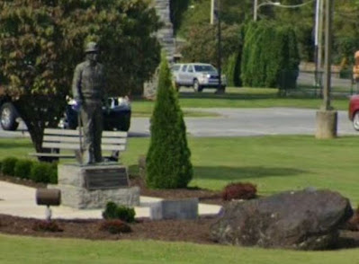
I suppose it is possible for a new person passing through Cornwall Center to notice briefly the statue of the man standing outside the elementary school and wonder whether it is of a farmer holding his shovel. Had he taken time off from a local field to build the school behind him? But why would he be wearing a helmet of all things? After all many a town has its patriotic monument, proud of its sons having gone off to war...  But no, that really wasn't meant to be a rifle at his side; it is a shovel. Perhaps someday you might slow down during your travel through "town," pull over and get out to read the inscription up close. While you're at it, take a "selfie" as a memento. If you are that person who is unaware, a very short distance from the statue is what remains of the largest open pit iron mine in the western hemisphere in the 18th century. It is now a "lake," which you may have noticed while driving out Boyd Street into Miners village. The Co...

About that title Photo

Image
The photo featured at the top of our website is the Robert H. Coleman Stables & Carriage House, the only remaining building on his former estate in Cornwall center.  This elegant building was constructed in the early 1880's. Although it still stands, it is mostly hidden on private property. During the wintertime you can catch a glimpse through the trees from Cornwall Road on your right as you approach the 419 intersection. Here are several other photos from those early days. It boggles the imagination that these structures once graced the center of our Borough. Caption: "Cornwall Hall," the second grand mansion that was built but never occupied. The original "Cottage" is visible in the back right corner. Caption: The Music Conservatory that housed Robert H. Coleman's water-powered organ. Organ music was one of his passions.

Virtual Tour - Historic Sites of Cornwall, Pennsylvania

Image
This  tour  is based on The Lebanon Valley Conservancy (TLVC.org) "Heritage Trail" map for our pleasant and historic Borough.  There are over 50 sites to visit so plan on taking your time, and feel free to return often. Your questions and comments are welcome. Click Here for the Virtual Tour   Instructions: On clicking the link above, your computer browser should take you to the Google Earth website. When in Google Earth, click the "Present" icon (see graphic below). This will give you the easiest way to navigate through the sites. Note: when using a cell phone or tablet, the "Present" icon is found by clicking the "three-dot" menu in the upper right, and then select the "Present document" option (see below). You may navigate back and forth through each site at your own pace by clicking on the forward (or reverse) arrow as shown in the graphic below. The rich features of Google Earth enhance your enjoyment as follows: You can explore...

Click "Follow" to Receive Notices of New Postings!

Questions? Contact Us:

Name

Email *

Message *